

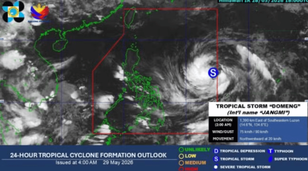
MANILA, Philippines — Even as millions across the country endure dangerous heat indexes, a significant shift in regional weather patterns is underway. State weather bureau PAGASA confirmed that while Tropical Storm Domeng (international name: Jangmi) is highly unlikely to make landfall, its massive atmospheric footprint will indirectly trigger widespread rain across the archipelago.
The storm has begun pulled in and enhancing the southwesterly windflow, signaling an aggressive transition toward the annual rainy season.
The weather system officially entered the Philippine Area of Responsibility (PAR) early Friday morning. It is rapidly gaining strength over open waters but remains safely tracking away from a direct hit:
[ Maximum Sustained Winds: 75 km/h ] ──► Gustiness Peaking Up to 90 km/h │ ▼ (Current Tracking Parameters)[ Current Location: 1,345 km East of Luzon ] ──► Moving Northwestward at 20 km/h │ ▼ [ Forecast Outlook: Expected to Intensify Into a Full Typhoon Category ]
Because the storm’s core is tracking far out over the Philippine Sea, PAGASA has not hoisted any Tropical Cyclone Wind Signals over any part of the landmass. However, its immense low-pressure circulation is acting like an atmospheric pump, dragging moisture-laden winds from the southwest straight into the country.
The arrival of the southwesterly windflow creates a stark contrast in the country’s daily weather grid. While 51 areas are concurrently tracking under “danger level” heat indexes on Friday, localized rain systems are beginning to break the dry spell:
                            [ GEOGRAPHIC WEATHER COMPOSITION ]
                                             │
         ┌───────────────────────────────────┴───────────────────────────────────┐
         ▼                                                                       ▼
   [ THE WESTERN RAIN TRACK ]                                              [ GALE-FORCE GUSTINESS BARORIES ]
   • **Target Areas:** The enhanced southwesterly flow is forecast to       • **Weekend Shift:** Beginning Saturday, May 30, strong to gale-force
     bring heavy, sustained rains over the western portions of Luzon,          gusts will begin sweeping across coastal and high-altitude sectors.
     Visayas, and parts of Mindanao.                                        • **Marine Warning:** Small seacraft are being advised to monitor coastal
   • **The Peak Window:** Heaviest downpours are expected to peak              conditions as offshore wave heights begin to climb.
     between **Sunday and Tuesday**.
The indirect rainfall comes at a critical juncture for the country’s infrastructure, which has been battered by a parched dry season.
| Affected Environmental Asset | Current Operational Status | Projected Storm Lifecycle Impact |
| National Water Reservoirs | Critical Deficit. Angat Dam sits at 177.45 meters, breaching its 180m minimum operating bar. | Early rains may saturate the forest floor, but it will require sustained, heavy watershed downpours to refill the basin. |
| Regional Power Grids | Extreme Strain. The Visayas grid is fluctuating under active Red and Yellow alerts due to plant failures. | Shifting cloud cover and cooler rainwater may help lower peak air-conditioning demands, easing grid load pressure. |
| Agricultural Sectors | Throttled. Water allocation for Central Luzon crops remains completely temporarily shut down. | The incoming rain provides a vital window for farmers to prepare fields, though sudden flash floods present a secondary risk. |
PAGASA weather specialist Benison Estareja noted that the storm’s trajectory will eventually carry it out of PAR toward Japan early next week. However, the southwesterly windflow it leaves behind will permanently lock in the country’s weather shift. Disaster response agencies are advising urban communities to clear local drainage systems over the weekend, warning that sudden localized cloudbursts hitting dried-up, hard soils could easily trigger flash floods and traffic delays across metropolitan hubs.