
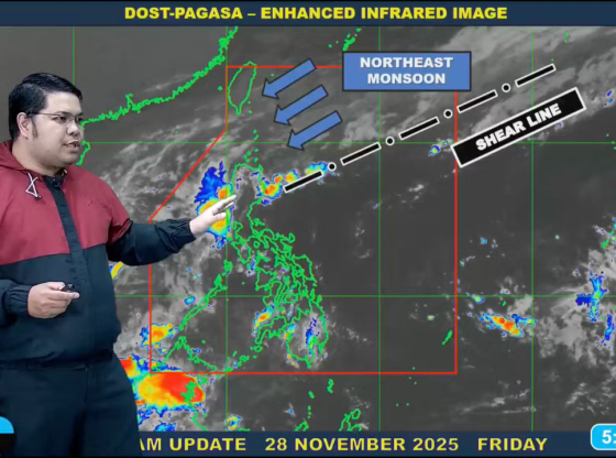
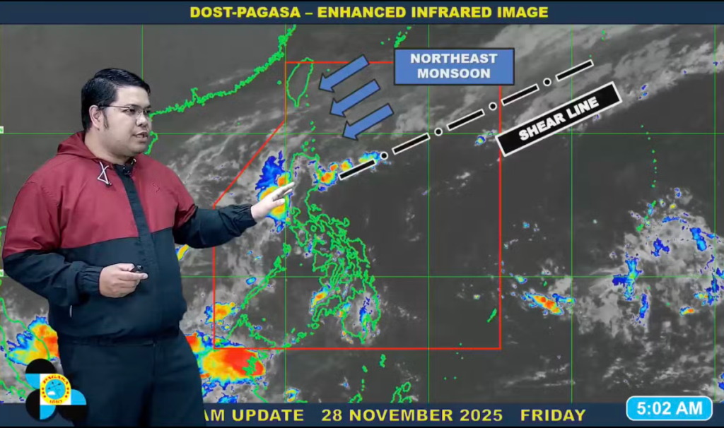
MANILA – As Filipinos fine-tune their holiday playlists and parol setups, Mother Nature is cranking up the volume on a soggy soundtrack for Luzon’s weekend: A potent shear line convergence, paired with the relentless northeast monsoon (amihan), is set to unleash scattered rains across the north and east, while the lingering trough of Severe Tropical Storm Verbena threatens to turn Palawan into a puddle paradise. The Philippine Atmospheric, Geophysical and Astronomical Services Administration (PAGASA) is waving a yellow flag for Saturday, November 30, urging residents to swap flip-flops for wellies and keep an eye on those gutters before the downpours dial up.
The forecast reads like a classic wet blanket over festivities: High chances of moderate to heavy rains in Cagayan, Kalinga, and Apayao, courtesy of the shear line – that invisible frontline where warm southern breezes butt heads with chilly northern fronts. “It’s the perfect storm setup for those areas,” explained PAGASA weather specialist Obet Badrina, his tone a mix of meteorologist caution and islander nonchalance. “Expect the works – from drizzles to deluges that could swell rivers and snag commutes.” Lighter showers are on tap for the rest of the Cordillera Administrative Region, Cagayan Valley, and pockets of the Ilocos Region, thanks to amihan’s steady clip.
But wait, there’s more splash: Localized thunderstorms are primed to rumble in the afternoons and evenings over Metro Manila, Central Luzon, Calabarzon (Cavite, Laguna, Batangas, Rizal, Quezon), Mimaropa (Mindoro, Marinduque, Romblon, Palawan), and the Bicol Region. Mornings might tease with fair skies until noon – a brief window for market runs or mistletoe hangs – before the clouds conspire. Over in Palawan, Verbena’s trough (the storm’s elongated rainy tail) is the uninvited guest crashing the party, packing maximum sustained winds of 95 kph and gusts up to 115 kph, last spotted 345 km northwest of Pag-asa Island in the Kalayaan group. “Palawan folks, buckle up – this could mean a washout,” Badrina added, with no gale warnings hoisted but moderate to rough seas churning off northern Luzon and Palawan waters.
The Visayas and Mindanao? A touch milder, with partly cloudy to cloudy skies and isolated rainshowers or thunderstorms popping up in the afternoons and evenings – enough to mist the malls but not monsoon the moods. And the good news amid the gloom? PAGASA pegs the odds of a new tropical cyclone bubbling up in the next two to three days as “less likely,” buying a brief breather from the cyclone circus.
Looking ahead, the four-day outlook keeps the taps trickling: Sunday to Monday sees the shear line and amihan tag-teaming eastern Northern Luzon, with scattered rains and thunderstorms lingering over Palawan’s Kalayaan Islands from Verbena’s wake. Tuesday flips to mostly fair with spotty storms, before a possible amihan surge doles out light rains to the north by Wednesday. Temperatures stay seasonably balmy: Metro Manila at 24°C to 31°C, Baguio’s chill at 17°C to 23°C, and Davao’s warmth at 24°C to 33°C – a reminder that even in the rain, the archipelago’s got that tropical hug.
Badrina’s bottom line? “Stay alert, especially if you’re in low-lying spots or near waterways – flash floods don’t RSVP.” For the weekend warriors plotting holiday hypes, it’s a call to pivot: Indoor caroling, anyone? As the shear line sharpens and amihan amps up, Luzon’s lesson is clear – in the Philippines, even Christmas comes with a side of splash.